3D Marine Vertical Cable Seismic

for Offshore Wind Site Characterization

Efficient · High-Resolution · Cost-Effective · Patent in Progress


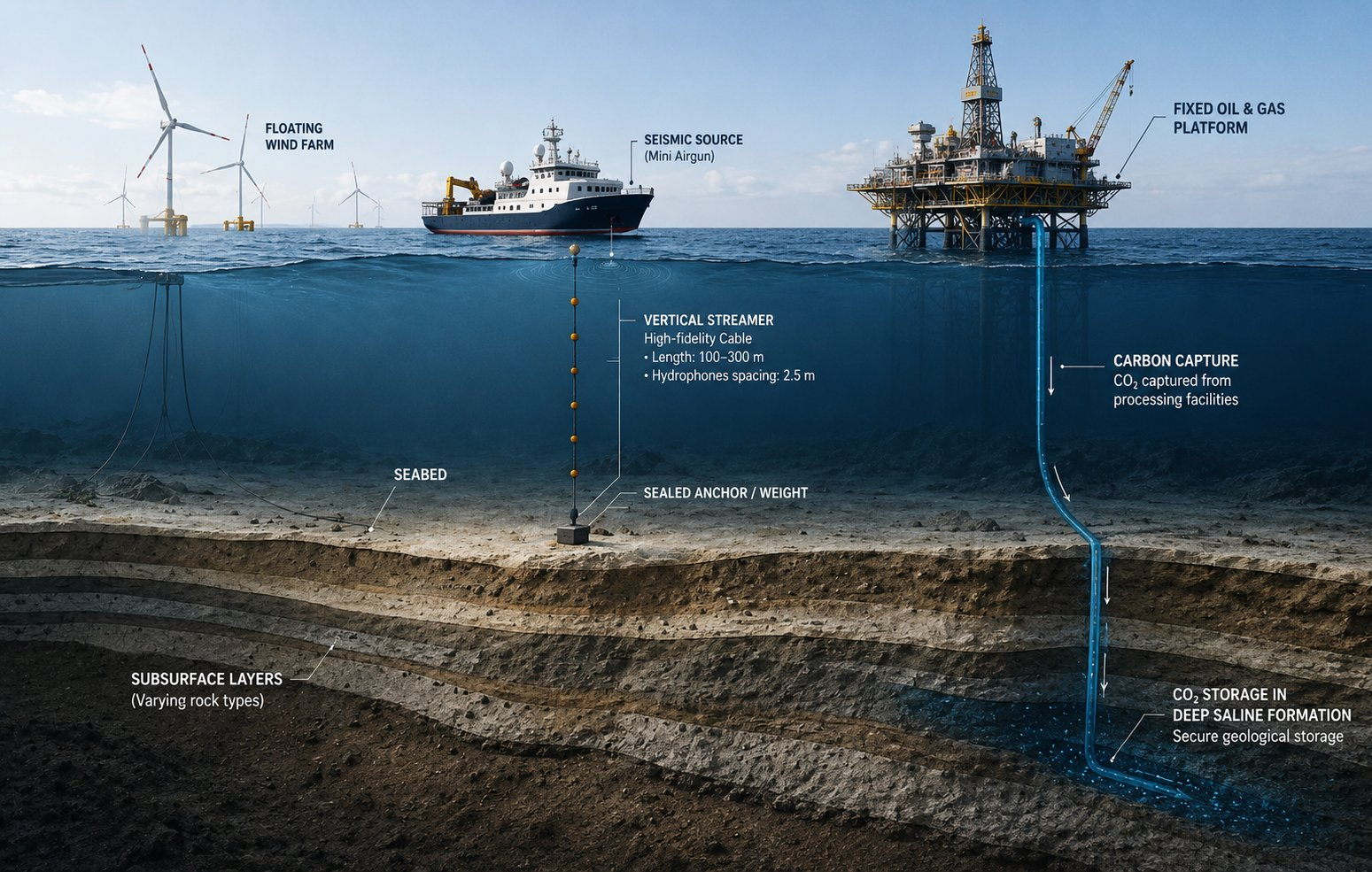
What is VCS?

3D Marine Vertical Cable Seismic (VCS) delivers site-specific high-resolution 3D subsurface models (0–100 m below seabed) at planned anchor and foundation locations.


Key Benefits

  • Reduce geotechnical uncertainty prior to CPT
  • Identify shallow hazards, boulders and weak layers
  • Superior data quality vs conventional 3D seismic
  • Cheaper & simpler than standard 3D surveys
  • Lower operational risk — small crews, fishing areas


Acquisition Concept

A vertical hydrophone cable (50–100 m) is anchored to the seabed. A seismic source (Sparker) is deployed from a survey vessel and shoots a spiral-coil pattern around each foundation location.


  • Vertical cable: 100–300 m, 2–5 m hydrophone spacing
  • Spiral Coil Acquisition — 100–200 m radius around foundations
  • 1–2 hours per foundation location
  • USBL transponders + 3-axis accelerometers for cable tracking
  • Upgoing (U) and down-going direct waves (D) at each depth

Fast-track Processing

  • Shot domain Up/Down wavefield separation (linear filter)
  • De-ghosting & de-multiple via up-down deconvolution
  • CRP migration (RadExPro)


Advanced Processing

  • Multi-depth sampling — natural wavefield separation like VSP
  • Enhanced de-ghosting — maximises usable frequency bandwidth
  • Vertical resolution is significantly higher than surface-towed systems
  • 3-Component analysis: hydrophone + accelerometers


Acquisition Layout

  • Targeted deployment — only necessary areas
  • Less vessel & equipment than standard 2D seismic
  • Flexible geometry for site-specific constraints
  • Rapid deployment for narrow weather windows
  • Pre-survey ray tracing & tomographic inversion

Market Applications

VCS addresses a broad range of shallow marine subsurface challenges:


Application

Depth

VCS Advantage

Offshore Wind

0–100m

Boulder detection, azimuth, resolution

CCS Monitoring

0–200m

4D repeatability, fluid detection

Cable & Pipeline

0–100m

Boulder, gas, full azimuth

Offshore Aggregate

5–50m

3D vs 2D UHRS

Geohazard

0–300m

Gas, slides, full resolution

UXO Investigation

0–10m

Diffraction imaging

Port & Harbour

0–50m

Compact footprint

Aquaculture

0–50m

Mooring characterisation


Why Now?

  • Global offshore wind boom driving demand
  • Reduced seismic budgets favour cost-effective methods
  • Demand for lower-emission, minimal-footprint surveys
  • Need for ultra-high-resolution shallow data at WTG locations

Partnership Model

Phase 1 — Concept & Pilot

A sweat equity pilot validates the technology in real offshore conditions using the partner's equipment.


VCS Team

  • Survey methodology & design
  • QC supervision
  • Processing & interpretation
  • Reporting & technical leadership
  • Core IP retained

Survey Partner

  • Vessel time & crew
  • Source/receiver equipment
  • Navigation systems
  • Offshore logistics & HSE
  • Mobilisation support


IP Structure

  • VCS Team retains core methodology, processing know-how, proprietary workflows
  • Survey partner retains equipment modifications, vessel procedures
  • Joint ownership: co-developed operational procedures & field techniques


The VCS Team

Juri Muzi

Design & Imaging

juri@vis-geo.com

Survey design, acquisition geometry, subsurface imaging and interpretation. Technical lead for methodology development.

Mathieu Milenkovich

Software & Processing

mathieu@vis-geo.com

Advanced processing workflows and software development. Milenkovic Consulting. Tomography, FWI integration.


Said Hedir

Operations & Design

                    said@vis-geo.com

Field operations, offshore system design, equipment deployment and HSE. Hands-on acquisition and processing expertise.


Why VCS?

vs Standard 3D Seismic

Applications

  • Faster acquisition (1–2 hrs/location)
  • Lower carbon footprint
  • Reduced vessel time & costs
  • Best-in-class shallow imaging
  • Smaller crews
  • Superior vertical resolution
  • Natural Up/Down wavefield separation
  • Full azimuth coverage at each WTG
  • VSP-style data quality from surface vessel
  • Flexible — adaptable to any site geometry
  • Offshore wind (fixed & floating)
  • CCS shallow monitoring
  • Cable & pipeline routes
  • Geohazard & UXO surveys
  • Offshore aggregate & aquaculture


Interested in a pilot partnership or commercial survey?  Contact the VCS Team.

V.I.S. — Verticale d'Imagerie Sismique  ·  Patent in progress